
April 13, 1984, marked a turning point in military history. Indian forces embarked on Operation Meghdoot to secure the Siachen Glacier. This wasn’t just another military campaign. It was a battle against nature itself at the world’s highest battlefield.
The Siachen Glacier presented challenges unlike any other conflict zone. Temperatures plummeted to -70°C. Soldiers faced altitudes where breathing became a struggle. No vegetation existed, no animals survived, and human habitation seemed impossible. Yet Indian forces pressed forward.
This comprehensive account examines how India secured control of Siachen. We’ll examine the strategic planning, the daring execution, and the ongoing defense. Additionally, we’ll understand why this frozen wasteland matters so critically to India’s security.
Understanding the Siachen Glacier
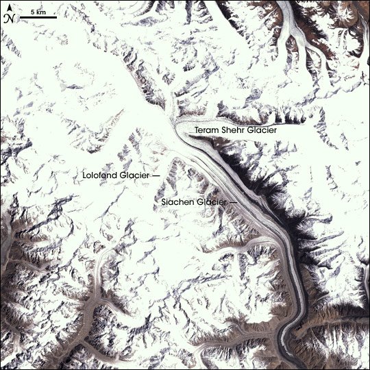
The Siachen Glacier sits in the eastern Karakoram Range. This massive ice formation stretches 76 kilometers in length. Consequently, it ranks as the longest glacier in the Karakoram. Moreover, it’s the world’s second-longest non-polar glacier.
Geographic Location and Features
Siachen Glacier begins at Point NJ9842 in the northeast. This point marks the end of the Line of Control. The glacier’s northern tip, Indira Col, sits approximately 5,911 feet above sea level. Even its lowest point reaches 11,000 feet.
The glacier’s highest military post stands at 22,000 feet. Flanked by Saltoro Ridge on the west, the glacier faces the Karakoram mountains eastward. These natural barriers create one of Earth’s most inhospitable environments.
Why Siachen Matters Strategically
The Siachen Glacier separates Central Asia from the Indian subcontinent. Pakistan borders it on one side, China on the other. This geographic position makes it invaluable.
If Pakistan controlled Siachen, direct connectivity with China would emerge. Furthermore, Pakistan could monitor the Ladakh region closely. The Leh-Srinagar highway would fall under strategic surveillance. This scenario would create serious security threats for India.
The 2020 clashes in Eastern Ladakh proved this point. Army Chief General MM Naravane highlighted Siachen’s importance. He identified it as critical to potential China-Pakistan collaboration. The glacier acts as a strong barrier between the two nations.
Key strategic advantages include:
- 24-hour surveillance capability over Pakistan and China
- Control over freshwater sources feeding the Indus River
- Prevention of Pakistan-China territorial linkage
- Early warning system for potential military movements
The Nubra River originates from Siachen, eventually joining the Indus. This river system sustains Pakistan’s Punjab plains through irrigation. Control over the water source provides India with diplomatic leverage. The Indus Waters Treaty governs water sharing between the two nations.
Historical Background of the Siachen Dispute
For decades after independence, no nation claimed Siachen. The extreme weather and difficult terrain discouraged military deployment. Both India and Pakistan considered the area uninhabitable. However, Pakistan’s actions in the 1970s changed everything.
Post-Independence Border Agreements
The 1949 Karachi Agreement followed India’s first war with Pakistan. Representatives from both nations drew a ceasefire line. This line extended from Manawar in the south to Khor in the north. Both countries defined their exact boundaries on the Jammu and Kashmir maps.
However, they ignored the Siachen area completely. The extreme weather conditions and difficult terrain made it seem irrelevant. This oversight would later create major complications.
Subsequently, the 1965 India-Pakistan war occurred. The Tashkent Agreement followed this conflict. Prime Minister Lal Bahadur Shastri and President Ayub Khan signed this pact. The ceasefire line became the Line of Control. Meanwhile, Siachen remained designated as “no man’s land.”
The Shimla Agreement and Territorial Claims
The 1971 war between India and Pakistan ended differently. Both nations signed the Shimla Agreement on July 2, 1972. This peace treaty established boundaries up to Point NJ9842.
Beyond NJ9842, the Siachen area remained unmarked on maps. India claimed rights based on earlier agreements. The 1947 Jammu and Kashmir Accession and the 1949 Karachi Agreement supported India’s position. These defined the ceasefire line extending “north to the glaciers.”
Conversely, Pakistan interpreted boundaries differently. They claimed areas beyond Saltoro Ridge extending northeast from Siachen. Pakistan insisted its boundary extended to the Karakoram Pass. This pass lies on China’s border.
Pakistan’s Mountaineering Strategy
Pakistan always wanted control over the Siachen area. During the 1970s and 1980s, they pursued a clever strategy. Pakistan began authorizing mountaineering expeditions in the region.
Foreign mountaineers received permits to climb the Siachen peaks. This authorization aimed to establish Pakistan’s territorial claim. If international expeditions used Pakistani permits, the area would gradually appear Pakistani.
India noticed this dangerous development. Unauthorized expeditions could legitimize Pakistan’s claims. Therefore, India responded strategically in 1978. They planned strong military mountaineering expeditions.

Colonel Narendra “Bull” Kumar led these expeditions. He was a renowned mountaineer in the Indian Army. Teams climbed several peaks, including Saltoro Kangri and Indira Col. Additionally, Indian forces began long-range patrols throughout the Siachen area.
The Catalyst: Discovery of Pakistan’s Plans
In 1977, German mountaineers approached India for climbing permits. They wanted to scale the Saltoro Range from India’s side. Although Pakistan’s route was easier, they chose the challenging Indian approach.
The Map That Changed Everything
Colonel Narendra met these German mountaineers during permit discussions. He examined the map they carried. What he discovered shocked him completely.
The map showed Siachen Glacier as Pakistani territory. This cartographic deception revealed Pakistan’s long-term strategy. Colonel Narendra immediately understood the situation’s gravity. He purchased the map from the Germans.
Without delay, he alerted Lieutenant General ML Chibber. Senior military officials studied all historical maps carefully. They discovered a disturbing pattern emerged over 15 years. Maps worldwide increasingly showed Siachen as Pakistani territory.
Military headquarters experienced immediate alarm. Everyone wondered about Pakistan’s next move. Intelligence agencies soon provided the answer. They revealed Pakistan’s Operation Ababeel plans.
Operation Ababeel: Pakistan’s Siachen Plan
Pakistan intended to launch Operation Ababeel soon. This operation aimed to capture the Siachen area. Indian military leaders realized immediate action was necessary. The Indian Army needed to establish control first.
Colonel Narendra suggested establishing permanent Indian posts in Siachen. Military leadership appreciated this strategic recommendation. Consequently, they honored him as the “Savior of Siachen.”
Planning for India’s response began immediately. The operation needed meticulous preparation despite enormous challenges. However, India couldn’t surrender Siachen to Pakistan. The strategic implications were too severe.
The London Supplier Incident
Pakistan’s Operation Ababeel required specialized equipment. Troops needed Arctic weather gear for Siachen’s extreme cold. They placed orders with a London supplier. Ironically, this supplier also served India.
When India placed similar orders, the supplier refused. They explained that Pakistan had placed a large order first. Supply limitations prevented fulfilling India’s request immediately.
This refusal alerted Indian intelligence completely. The race to Siachen suddenly became urgent. India accelerated their operation planning dramatically. Pakistani officers later admitted they missed Siachen by mere days.
Planning Operation Meghdoot
Army headquarters discussed the Siachen capture plan extensively. Securing Siachen wouldn’t be easy under any circumstances. Nevertheless, India couldn’t allow Pakistani control. Chief of Army Staff General Arun Vaidya approved the operation.
Prime Minister Indira Gandhi and the Cabinet Committee granted permission. The Indian Army would capture all critical Saltoro Ridge peaks. Before starting, they named it Operation Meghdoot.
Troop Selection and Training
The Indian Army decided to deploy specialized troops. They selected personnel from the northern Ladakh region and paramilitary forces. Most troops came from the 1982 Antarctica training expedition. These soldiers had experienced similar cold and terrain.
Training covered several specialized skills:
- Ice craft and snow craft techniques
- Survival in extreme conditions
- Physical fitness at high altitude
- Mental robustness and psychological preparation
However, Pakistan was also preparing simultaneously in 1983. Pakistani generals planned to deploy troops to the Siachen area. They feared India would use the previous expeditions advantageously. Pakistan wanted to reach the glacier first.
Leadership and Command Structure
Lieutenant General PN Hoon received overall operational leadership. Major General Shiv Sharma and Lieutenant General ML Chibber assisted. Brigadier Vijay Channa of 26 Sector commanded the Saltoro Ridge capture.
The operation window spanned April 10-30, 1984. Commander Channa chose April 13 strategically. This date coincided with Baisakhi festival celebrations. Pakistan wouldn’t expect India to launch operations during festivities.
The Four Critical Passes
Operation Meghdoot targeted four important mountain passes:
- Sia La
- Bilafond La
- Gyong La
- Lungla
Capturing these passes meant controlling Indira Col. This northernmost point of Siachen was strategically vital. Securing these passes would prevent Pakistan permanently.
Lieutenant Colonel Pushkar Chand became Task Force Commander. Captain Sanjay Kulkarni headed operations toward Bilafond La. Major AK Bahuguna led Ladakh Scouts toward Sia La. Lieutenant Colonel DK Khanna commanded 19 Kumaon toward Gyong La.
Execution of Operation Meghdoot
On April 13, 1984, at 5:30 AM, operations commenced. Cheeta helicopters took off carrying troops toward Bilafond La. Despite poor visibility and dropping temperatures, flights continued. Pilots completed 17 sorties throughout the day.
All Indian troops reached Bilafond La successfully. Multiple helicopter types participated, including AN-32 and MI-8. The Indian Air Force handled all airlift operations.
Extreme Challenges at Bilafond La
Just three hours after landing, challenges emerged immediately. One soldier developed High Altitude Pulmonary Edema (HAPE). He was the radio operator, unfortunately. Communication with headquarters broke down completely.
A massive snowstorm engulfed the area simultaneously. This fierce blizzard isolated troops for three days. On April 16, supplies finally reached the stranded soldiers. However, one soldier already suffered severe frostbite.
Despite brutal conditions, soldiers established camps by April 15. Their determination overcame nature’s fury completely. By April 17, operations expanded toward Sia La.
Securing the Strategic Peaks
Five Cheeta and two MI-8 helicopters flew 32 sorties to Sia La. Finally, the Indian tricolor flew atop Bilafond La and Sia La. By April 17, approximately 300 Indian Army troops controlled critical peaks.
Meanwhile, Lieutenant Colonel DK Khanna approached Gyong La cautiously. This peak stood highest and most dangerous on Saltoro Ridge. Progress was necessarily slow but steady. Troops expected to secure it by early June.
However, Pakistan launched its climbing attempt on April 17. Indian troop movements became visible to Pakistani forces. Actually, Pakistan detected India earlier through radio intercepts.
The First Casualty and Radio Compromise
An Indian soldier died from extreme cold exposure. Troops used the radio to request proper burial arrangements. They knew this transmission would alert Pakistan. Nevertheless, honoring their fallen comrade took priority.
Their fears proved correct almost immediately. Pakistan learned about Indian movements through intercepted communications. They quickly prepared the Burjil Force under Operation Ababeel. Pakistan chose June 23 for their attack.
The Battle of Bilafond La
Pakistan attacked Indian positions at approximately 5:30 AM. The assault began at Bilafond La, where Captain Kulkarni established positions. India had built several camps with surveillance posts.
Lance Naik Chanchal Singh was on watch duty. He suddenly spotted Pakistani soldiers moving below Bilafond La. Singh immediately alerted Captain Kulkarni about the enemy attack.
Chanchal Singh’s Supreme Sacrifice
All Indian soldiers quickly assumed defensive positions. However, Pakistani firing was intense and dangerous. During this firefight, a Pakistani soldier shot Lance Naik Chanchal Singh.
The bullet killed Singh instantly on the spot. He became Operation Meghdoot’s first battlefield casualty. This loss enraged Indian forces completely. They vowed to defeat Pakistan decisively.
An Indian soldier immediately shot the Pakistani who killed Singh. Fierce fighting continued at this extreme altitude. Nevertheless, India decisively defeated Pakistan’s attack. Pakistan lost 26 soldiers while India lost one.
Subsequent Pakistani Attacks
Pakistan didn’t stop after this initial defeat. They attacked again in June with similar results. India repelled this assault, crushing Pakistan once more.
August 1984 saw two additional Pakistani attacks. Indian soldiers crushed both attempts effectively. These battles cost Pakistan 30 more soldiers. Meanwhile, Indian forces captured Gyong La at 5,700 meters.
Captain DK Khanna and his team secured this challenging peak. India now controls all four critical Saltoro Ridge passes:
- Sia La
- Bilafond La
- Gyong La
- Chulu La
Siachen now belonged to India completely. However, maintaining control would prove equally challenging.
Defending Siachen: Post-Operation Challenges
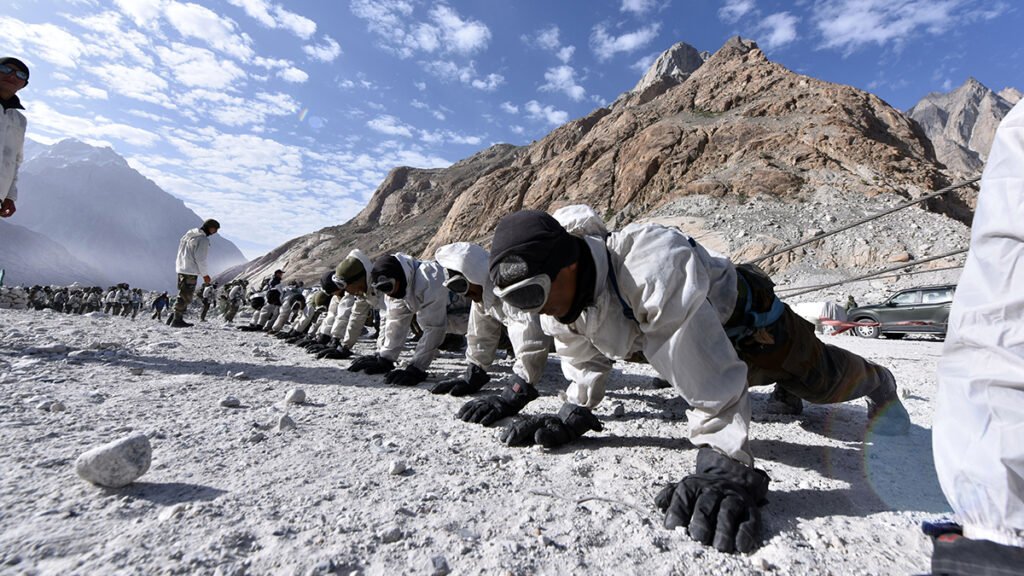
Establishing control over Siachen wasn’t easy initially. The biggest enemy wasn’t Pakistan but the extreme cold. Temperatures that ordinary people couldn’t imagine surviving. Yet Indian Army soldiers persevered with courage.
Converting Camps to Permanent Posts
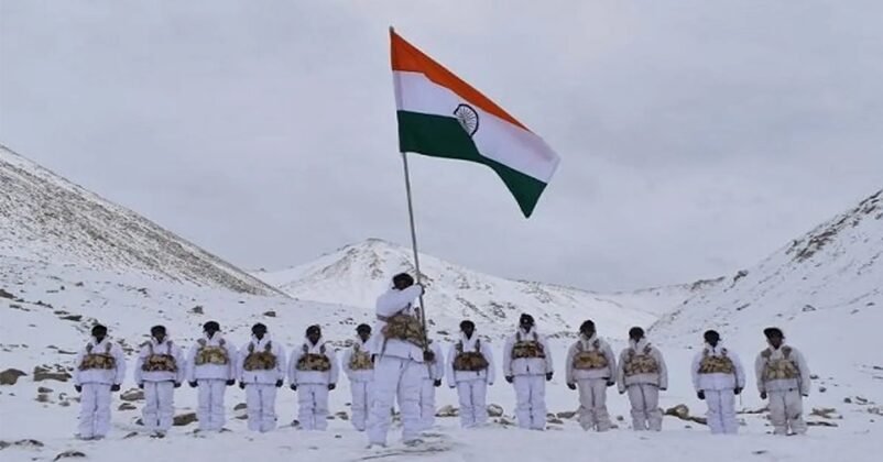
Shortly after victory, India converted camps into permanent posts. Continuous surveillance began immediately across the glacier. Soldiers rotated regularly to maintain a constant presence.
Operation Meghdoot was a unique war indeed. Weather conditions killed more soldiers than enemy bullets. Extreme cold and harsh conditions claimed many lives. Since 1984, nearly a thousand Indian soldiers died defending Siachen.
Soldiers face multiple life-threatening challenges daily:
- High winds exceeding 100 km/h
- Altitude sickness and oxygen deprivation
- Severe frostbite requiring amputations
- Temperatures are dropping below -50°C regularly.
Nevertheless, Indian soldiers remain ready for every challenge. They serve with pride, protecting India’s sovereignty. Their sacrifice ensures national security remains uncompromised.
Subsequent Military Operations
Pakistan continued attempting to recapture Siachen repeatedly. Indian forces successfully repelled every single attempt. However, April 1986 saw Pakistan establish Quaid Post.
Operation Rajiv and Bana Top
Pakistani forces captured Siachen’s highest peak south of Bilafond La. They established a military post, naming it Quaid Post. This audacious move demanded an immediate Indian response.
In June 1987, India launched Operation Rajiv decisively. Pakistani forces were driven out once again. Naib Subedar Bana Singh led this dangerous operation. His exceptional bravery earned him the Param Vir Chakra.
Honoring his courage, Quaid Post became Bana Post. This renaming celebrated India’s victory and Singh’s heroism. The post remains under Indian control today.
Operation Vajra Shakti
Later in 1987, Brigadier General Pervez Musharraf tried to recapture the post. He launched Operation Qiadat for this purpose. India responded with Operation Vajra Shakti immediately.
Pakistan faced another humiliating defeat conclusively. Musharraf’s forces retreated without achieving objectives. India maintained its firm grip on Siachen.
Continued Defense Operations
March 1989 brought Operation Ibex targeting Pakistani posts. This operation focused on positions overlooking Chumik Glacier. Once again, Indian forces succeeded completely.
In 1992, Operation Trishul Shakti defended Chhullu’s Bahadur Post. Pakistani assault teams attacked but failed miserably. India repelled them successfully, maintaining control.
The 1995 Battle of Tulung La Post tested Indian resolve. Pakistan attacked this post along the southern Saltoro defense borders. Victory belonged to India once more.
Pakistan made numerous attempts over the subsequent years. Not once did they succeed in dislodging Indian forces. Indian soldiers consistently defeated Pakistani military operations.
Operation Meghdoot’s Lasting Impact
Through Operation Meghdoot, India reclaimed strategically vital territory. The operation’s results are clear and measurable. Today, India controls approximately 76 kilometers of the Siachen Glacier. Additionally, India administers about 2,500 square kilometers of surrounding territory.
Pakistan launched the 1999 Kargil War, partially hoping to capture Siachen. That conflict also ended in Pakistan’s defeat. India’s hold on Siachen remains absolutely unshakeable.
The Human Cost
Maintaining Siachen control demands tremendous sacrifice continuously. The glacier’s defense requires constant vigilance and courage. Since assuming control in 1984, approximately 1,000 Indian soldiers died.
Most deaths result from weather-related causes rather than combat:
- Avalanches bury entire posts.
- Crevasse falls during patrols.
- Frostbite complications and amputations
- High altitude cerebral edema
- Hypothermia during blizzards
Despite these dangers, soldiers serve with unwavering dedication. They understand Siachen’s critical importance to national security. Their sacrifice protects millions of fellow citizens.
Conclusion
Operation Meghdoot stands among India’s greatest military achievements. Launched on April 13, 1984, it secured the world’s highest battlefield. Indian forces overcame impossible odds, conquering nature itself.
The Siachen Glacier represents more than frozen wasteland. It symbolizes Indian military prowess and strategic foresight. Control over Siachen prevents Pakistan-China territorial connectivity. Moreover, it provides India with crucial surveillance capabilities.
Today’s soldiers continue this legacy of sacrifice and courage. They endure unimaginable hardships protecting our borders. Their dedication ensures India’s sovereignty remains intact. Operation Meghdoot reminds us that determination conquers all obstacles. The Indian tricolor flies proudly over Siachen today. It will continue flying there tomorrow and always.