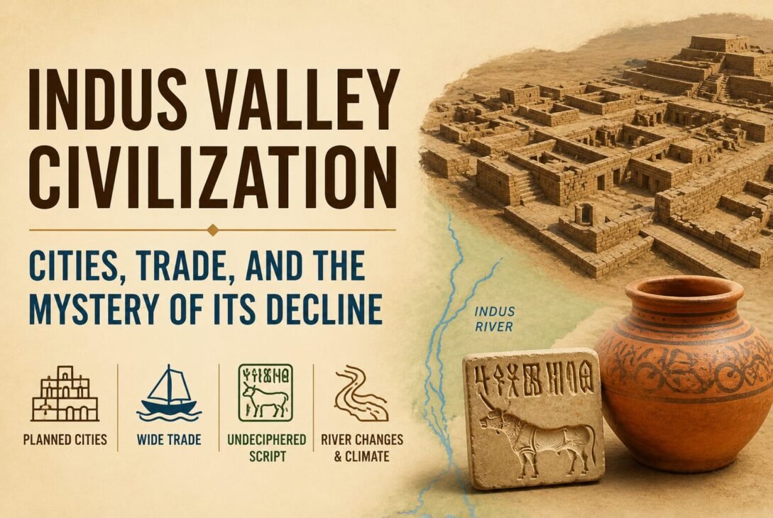
Around 2600 BCE, while Egypt was raising its pyramids and Mesopotamia was consolidating its city-states, a third great urban civilisation emerged quietly in South Asia. It left no royal tombs filled with golden treasure, no boastful inscriptions naming its kings, and no army of scribes recording its conquests. What it left instead were drains.
Precisely laid brick drains, running under planned streets, connecting to covered sewers, carrying wastewater away from thousands of homes across cities that stretched from what is now Pakistan’s Sindh province to Gujarat’s Rann of Kutch. The Harappan Civilization — also called the Indus Valley Civilization — is one of the earliest large urban systems in human history, and in many ways one of the most unusual: a Bronze Age world that apparently organised itself without the markers we expect from great ancient powers.
This article covers the Harappan Civilization’s major cities, what archaeology tells us about how they were built and how they traded, and why — after roughly seven centuries of urban life — the cities gradually fell silent after about 1900 BCE. Where evidence is strong, we state it plainly. Where interpretation is genuinely contested, we say so.
Quick Reference: Harappan Civilization at a Glance
| Feature | Detail |
| Other name | Indus Valley Civilization |
| Mature urban phase | c. 2600–1900 BCE |
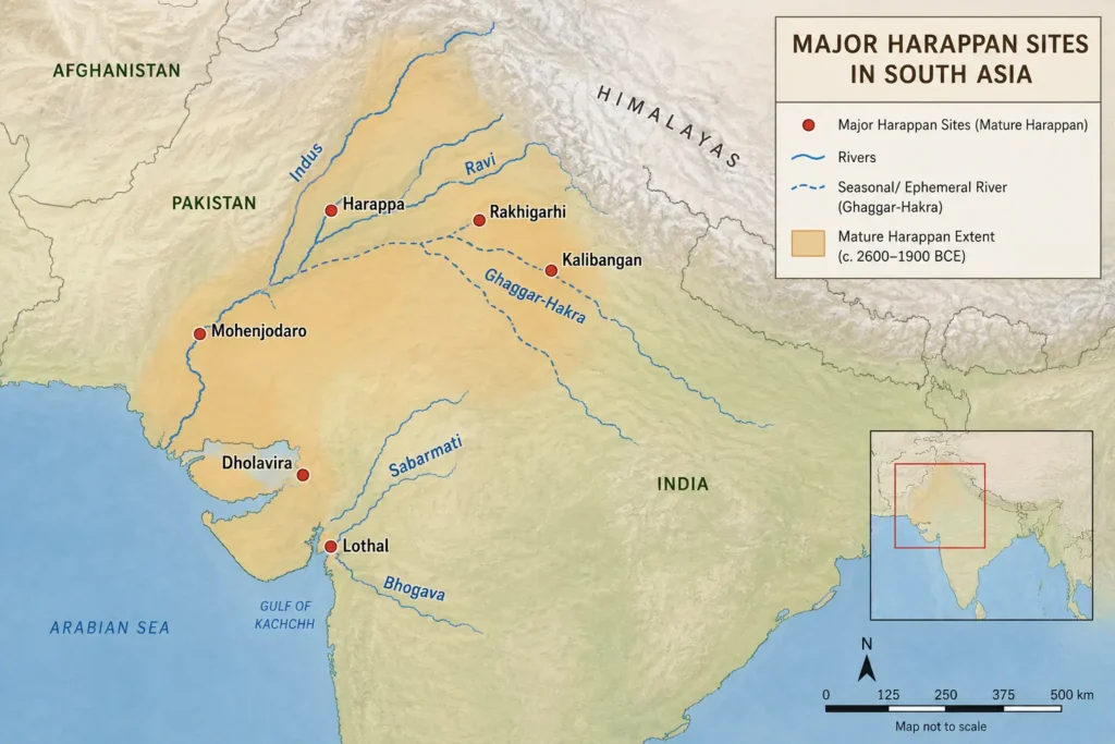
| Geographic spread | Pakistan, northwestern and western India; from Afghanistan to Maharashtra |
| Major cities | Harappa, Mohenjodaro, Dholavira, Lothal, Rakhigarhi, Kalibangan |
| Script | Known but undeciphered |
| Trade connections | Mesopotamia, Dilmun (Bahrain), Magan (Oman) |
| Discovery announced | 1924, by archaeologist John Marshall |
| UNESCO sites | Mohenjodaro (1980), Dholavira (2021) |
| Governing body for sites in India | Archaeological Survey of India (ASI) |
Why It Is Called the Harappan Civilization
The civilization is known by two names used interchangeably. “Indus Valley Civilization” refers to the river system — the Indus and its tributaries — around which many major sites cluster. “Harappan Civilization” is named after Harappa (in present-day Pakistan’s Punjab province), the site through which archaeologists first identified this broader cultural tradition.
The sequence of discovery matters. In 1875, Alexander Cunningham had noticed an unusual seal from Harappa. But it was only after Daya Ram Sahni began systematic excavations at Harappa in 1921 and Rakhal Das Banerji began work at Mohenjo-daro in 1922 that the scale of what lay underground became clear. In 1924, John Marshall publicly announced the discovery of a new and previously unknown civilisation.
The name “Harappan” stuck in academic usage because the convention in archaeology is to name a culture after the site where it was first identified, even if later excavations reveal larger or better-preserved sites elsewhere.
The Geographic Reach: Larger Than Egypt and Mesopotamia Combined
The Harappan world was vast. Archaeological material associated with this civilisation has been found across a zone spanning present-day Pakistan and northwestern to western India — from Afghanistan in the north to Maharashtra in the south, covering Punjab, Haryana, Rajasthan, Uttar Pradesh, and Gujarat.
This made it geographically the largest of the three great Bronze Age civilisations of the ancient world. Not the most famous — Egypt’s monuments and Mesopotamia’s written records have always attracted more attention — but the most widely spread.
The settlement pattern was not uniform. Some sites were major urban centres. Others were smaller towns, craft production centres, agricultural villages, or coastal trading posts. The civilisation’s scale becomes clearer when you understand that archaeologists have identified more than a thousand Harappan sites in total, of which a handful were true cities.
Major Harappan Cities and Archaeological Sites
Harappa
Harappa (in present-day Punjab, Pakistan) is the site that gave the civilisation its academic name. Excavations beginning in 1921 revealed an urban centre with a raised fortified area, large granary-like structures, worker housing, and evidence of craft production. It sits on the banks of the Ravi, a tributary of the Indus.
Mohenjodaro
Mohenjo-Daro (in Sindh, Pakistan) is arguably the most studied Harappan city, and a UNESCO World Heritage Site since 1980. The city was divided into two broad zones: a raised Citadel and a larger Lower Town. Streets in the Lower Town followed an approximate grid pattern, intersecting at right angles. Houses commonly had courtyards, brick-paved bathrooms, and drains connected to covered street-level channels. Scholars have estimated roughly 700 wells in the city.
Harappan bricks were produced to standardised proportions — a ratio of approximately 1:2:4 in height, breadth, and length — found consistently across sites spread hundreds of kilometres apart. That kind of uniformity across such distances is striking and suggests some shared norm, though whether it arose from a central authority or from shared craft tradition remains debated.
Dholavira
Dholavira (in the Rann of Kutch, Gujarat) was inscribed as a UNESCO World Heritage Site in 2021, and is described in its UNESCO dossier as one of the most well-preserved urban settlements of the Mature Harappan period. UNESCO notes it was occupied for roughly 1,500 years.
What makes Dholavira distinctive is its water management system. Built in a semi-arid landscape with limited reliable water, the city’s planners engineered a network of large reservoirs, channels, and storage structures designed to capture and retain monsoon rainwater. UNESCO describes the city’s layout as a fortified complex with a castle, a bailey, a ceremonial ground, a middle town, and a lower town — each zone carefully delineated. It is also the site of what appears to be a large Harappan signboard, with sign characters that, if confirmed, would represent one of the earliest public uses of the script.
Dholavira also uses significantly more stone in its construction than sites like Mohenjodaro — a reminder that the Harappan world was not a single template applied uniformly everywhere.
Lothal
Lothal (in Gujarat, on the Gulf of Khambhat) is famous primarily as a potential Harappan port town. The site includes a large basin that the UNESCO tentative-list dossier interprets as a tidal dockyard, along with warehouse remains, planning evidence, and signs of industrial activity, including bead-making.
A careful note: the dockyard interpretation is widely accepted in educational sources but is not without scholarly debate. The safe phrasing is that Lothal’s basin is widely interpreted as a maritime dockyard, not that it is definitively proven.
Rakhigarhi
Rakhigarhi (in Haryana) is described by Haryana Tourism as one of the largest Harappan townships on the subcontinent, with evidence of planned settlement, drainage, and seals. Excavations began there in 1997. It is significant for both its scale and for being among the better-studied Harappan sites located within present-day India.
Kalibangan
Kalibangan (in Rajasthan, on the Ghaggar-Hakra) is notable for evidence of a ploughed field — intersecting furrows — that many scholars interpret as indicating mixed or intercropped cultivation. It also yielded evidence of structures interpreted as fire altars, though those identifications require careful wording (see the Religion section below).
Urban Planning: What Made Harappan Cities Distinctive
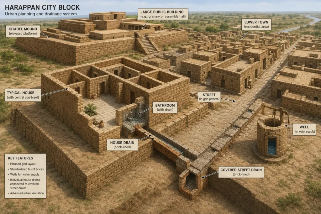
Image generated by AI for reference purposes.
The Harappan Civilization’s urban infrastructure is its most immediately striking feature, especially when you consider it was built during the Bronze Age without iron tools.
The key elements, verified archaeologically:
- Grid-pattern streets: Roads in Mohenjo-Daro’s Lower Town intersected at right angles, with major streets and smaller lanes forming a structured layout.
- Standardised brick: The consistent 1:2:4 proportions across distant sites are well-documented.
- Household drainage: Homes had bathrooms with floors that sloped toward drains; wastewater moved through brick-lined channels into covered street drains. This is among the most extensive drainage systems known from the ancient world.
- Wells: Mohenjo-Daro alone had roughly 700 wells providing household water access.
- Reservoirs: Dholavira’s elaborate system of reservoirs and water channels adapted to a semi-arid environment represents the most sophisticated Harappan water management documented so far.
- Fortification: Multiple sites show raised, walled areas that are typically described as citadels — elevated zones that may have housed grain storage, public buildings, and elite structures.
The Great Bath at Mohenjo-Daro — a large, watertight, brick-lined tank on the citadel — is the site’s most famous structure. It is commonly interpreted as a ritual bathing facility, but that interpretation, while plausible, is not confirmed by any deciphered text.
What the infrastructure as a whole reveals is a civilisation capable of coordinating large-scale public works across multiple cities simultaneously. Whether that coordination came from a central political authority, regional elites, or shared craft norms is one of the unresolved questions of Harappan archaeology.
Economy: Agriculture, Craft, and Standardised Exchange
The Harappan economy was built on mixed agriculture, animal husbandry, specialist craft production, and long-distance trade. Archaeological evidence for all four is solid.
Agriculture: Identified crops include wheat, barley, lentil, chickpea, and sesame, with millets especially associated with Gujarat sites and rice comparatively rare in the Harappan record. Animal bones at sites include cattle, sheep, goat, buffalo, and pig, along with wild species and fish.
Craft specialisation: Harappan artisans produced shell ornaments, faience, terracotta figurines, steatite seals, agate and carnelian beads, copper and bronze tools, and pottery. Evidence of dedicated workshops suggests craft was organised as a specialised occupation rather than a household sideline.
Standardised weights: Trade within and beyond the Harappan world used a system of standardised stone weights — lower denominations following a binary sequence, higher denominations in decimal multiples. These weights have been found across a wide geographic range, which suggests they functioned as a shared commercial standard.
Seals and sealings: Thousands of carved steatite seals — bearing animal motifs and script signs — were likely used to identify the sender of goods and to seal packages in long-distance trade.
Harappan Trade with Mesopotamia: The Meluhha Connection
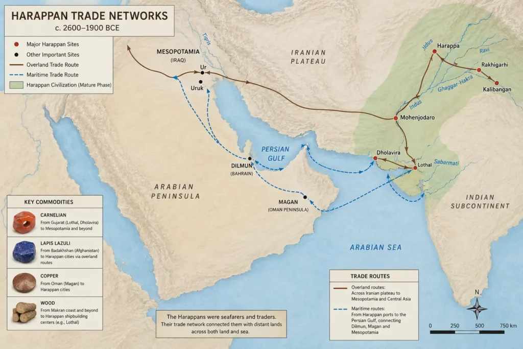
The Harappan Civilization was not an isolated world. Mesopotamian textual sources from the third millennium BCE mention a trading partner called Meluhha, associated with commodities including carnelian, lapis lazuli, copper, gold, and wood. Many archaeologists identify Meluhha with the Harappan region. This is an interpretation — no Harappan inscription has been found saying “we are Meluhha” —, but it is the mainstream scholarly consensus.
Physical evidence corroborates the connection. Harappan-style seals, weights, and beads have been found at Mesopotamian sites. UNESCO’s dossier on Dholavira explicitly notes the site’s links with Oman and the broader Gulf region. Research into ancient trade documents, Indus material in the Oman Peninsula.
The trade network extended through two named intermediaries in Mesopotamian sources: Dilmun (associated with present-day Bahrain) and Magan (associated with the Oman Peninsula). These appear to have been relay points in a larger Gulf trading system connecting South Asia to the Near East.
Lothal’s large basin — interpreted as a tidal dockyard — suggests that at least some of this trade moved by sea. The site’s warehouse remains and bead-working evidence fit the profile of a coastal trading and processing centre.
The practical implication of all this evidence is that Harappan merchants, seals, and goods reached civilisations thousands of kilometres away. This was not local commerce. It was a Bronze Age international trading system.
The Indus Script: The Puzzle That Remains Unsolved
The Harappan Civilization had a script. We know this because we have thousands of examples — carved on steatite seals, stamped on pottery, inscribed on copper tools, bone rods, jewellery, and tablets, and displayed on what appears to be a large signboard at Dholavira.
What we do not have is a single accepted reading of any of it.
The script has a sign inventory that scholars estimate at roughly 375 to 400 signs, with some counts going higher. Most inscriptions are very short — the longest known inscription has about 26 signs. This brevity, combined with the absence of any confirmed bilingual inscription (the kind of find that unlocked Egyptian hieroglyphics), means that decipherment has not been achieved despite more than a century of attempts.
A significant scholarly debate runs beneath the surface. One position, associated with researchers including Rajesh P.N. Rao and colleagues, holds that the sign ordering shows statistical patterns consistent with linguistic writing. A dissenting position, advanced by Steve Farmer, Richard Sproat, and Michael Witzel, argues that the sign system may have been a non-linguistic symbol system rather than true writing in the full sense. The debate is unresolved, and neither side has definitively carried the field.
The ASI’s own publication on the script’s current status notes it remains undeciphered, with right-to-left writing tendency and a sign corpus of over 400 signs.
What this means practically: any article, video, or social media post claiming the Indus script has been “solved” or “decoded” — in Sanskrit, Tamil, or any other language — should be treated with scepticism unless backed by broad scholarly acceptance, which does not currently exist.
Why Did the Harappan Civilization Decline?
This is the question that has attracted the most popular attention, the most contested theories, and also the most significant recent scientific progress. The short answer: the Harappan urban system did not collapse suddenly. It de-urbanised gradually, over centuries, for reasons that were almost certainly multiple and interacting.
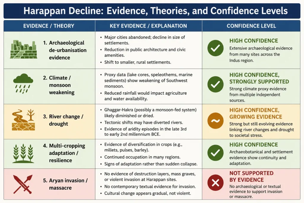
What the Archaeological Evidence Shows
After about 1900 BCE, a set of distinctive urban markers began to disappear from the Harappan record. Standardised seals, script, uniform weights, special beads, long-distance trade goods, and large public construction projects all became less common or disappeared from former major sites.
By around 1800 BCE, many Mature Harappan sites in the Cholistan region (present-day Pakistan) had been abandoned. But populations did not simply vanish — settlement evidence shows a shift eastward and southward, into Gujarat, Haryana, and western Uttar Pradesh. This is better described as de-urbanisation and regional reorganisation than as extinction.
Climate and River Change: The Strongest Explanatory Framework
The leading scientific explanation for the Harappan transformation involves climate stress — specifically, changes in monsoon patterns and river behaviour.
Research published in the Proceedings of the National Academy of Sciences (2012) by Liviu Giosan and colleagues modelled the fluvial landscapes of the Harappan civilisation and argued that the rivers sustaining settlement were monsoon-fed rather than perennial Himalayan-sourced waterways, making them vulnerable to changes in seasonal rainfall patterns.
Research published in Scientific Reports (2018) links wetter monsoon conditions with the urban phase of Harappan civilisation and connects the subsequent drying trend with the later eastward population shift.
A 2025 study in Communications Earth & Environment by Solanki and colleagues identified evidence of severe and persistent river droughts and argued these likely contributed to dispersal from major Harappan centres — while explicitly framing the process as one of complex interplay between climatic, social, and economic pressures, not a single cause.
The key phrase in all of this is likely contributed — climate and river change are the strongest explanations currently available, but responsible scholarship does not present them as the single, proven cause.
Adaptation and Resilience: The Other Part of the Story
Work by Cameron Petrie, Jennifer Bates, and colleagues emphasises crop diversity and multi-cropping strategies as evidence that Harappan communities were not simply passive victims of environmental change. Their agriculture was regionally adapted, using different crop combinations in different zones, which suggests a degree of resilience that makes a simple environmental-collapse narrative incomplete.
The picture that emerges is of a civilisation that adapted for a long time, shifted its settlement patterns, and eventually reorganised into smaller, post-urban communities rather than disappearing. Some regional archaeological cultures that come after the Mature Harappan period — Late Harappan and successor cultures — show clear continuities in pottery and other material culture.
What About the Aryan Invasion Theory?
For most of the twentieth century, a popular explanation for Harappan decline was that incoming Aryan-speaking peoples invaded from the northwest, sacked Harappan cities, and brought the civilisation down. The most dramatic version of this theory — associated with archaeologist R.E.M. Wheeler — pointed to skeletal remains at Mohenjodaro as evidence of a massacre.
Later archaeological re-evaluation, associated with George F. Dales, thoroughly challenged this interpretation. Dales found no evidence of a destruction layer that could explain the overall decline, no evidence of final military defence preparations at Mohenjo-Daro, and significant problems with Wheeler’s reading of the skeletal evidence.
The invasion/massacre theory is no longer the standard archaeological explanation for Harappan decline. Presenting it as the consensus answer in a UPSC or academic context would be factually incorrect.
Society, Governance, and Religion: What We Don’t Know
The Harappan Civilization presents a recurring frustration for historians: a great deal of material evidence, and almost no direct textual record explaining the society behind it.
Governance: The uniformity of bricks, weights, seals, and pottery across such a large area suggests some mechanism of coordination — but archaeology does not tell us whether this came from a single state, multiple regional rulers, or shared cultural norms without formal political hierarchy. NCERT explicitly notes that scholars disagree on all three possibilities. A building at Mohenjo-Daro was once labelled a “palace” and a carved figure a “priest-king,” but neither identification is certain.
Burials: Harappan burials sometimes include pottery and ornaments, but do not generally display the kind of extreme wealth concentration seen in, say, Egyptian royal tombs. This has been interpreted as evidence of relatively modest social differentiation, but it is an inference from absence.
Religion: Terracotta female figurines have been called “mother goddesses,” and a seated figure on a seal has been called “proto-Shiva.” Both are plausible interpretations; neither is proven. NCERT explicitly cautions that such identifications become speculative when extended to claim direct religious continuity with later Hindu traditions. Fire-altar-like structures have been reported at Kalibangan and Lothal, and the Great Bath is interpreted as a ritual structure — but all of these remain archaeological interpretations, not confirmed facts. Writing about Harappan religion requires consistent use of hedging language: interpreted as, may represent, and possible parallel to.
Frequently Asked Questions
Why is it called the Harappan Civilization?
It is named after Harappa, the site through which the civilisation was first identified by archaeologists in 1921. “Indus Valley Civilization” is the other common name, referring to the river system around which many major sites are located.
Which was the largest Harappan city?
Rakhigarhi (in Haryana) and Mohenjo-Daro have both been described as among the largest Harappan sites. Claims about “the single largest” depend on the measurement method and continue to be debated as excavation data from newer sites becomes available.
Has the Indus script been deciphered?
No. The script remains undeciphered. Most inscriptions are very short (the longest has about 26 signs), no bilingual inscription has been found, and scholars continue to debate even whether it encoded language in the same way as other ancient scripts.
Did Aryans destroy the Harappan Civilization?
This is not the standard archaeological explanation today. Re-evaluation of the evidence by George Dales and others found no destruction layer and no evidence of final military defence consistent with a civilisation-wide invasion. The de-urbanisation of the Harappan world appears to have been a gradual process spanning centuries.
Why is Dholavira important?
Dholavira is important for its exceptional state of preservation, its distinctive multi-part fortified urban layout, and above all, its sophisticated water management system — an elaborate network of reservoirs and channels designed for a semi-arid environment. It became a UNESCO World Heritage Site in 2021.
Did the Harappans trade with Mesopotamia?
Yes. Archaeological evidence and Mesopotamian textual references — particularly to a trading partner called Meluhha — support the existence of sustained long-distance exchange between the Harappan region and Mesopotamia, Dilmun, and Magan. Goods, including carnelian, copper, and lapis lazuli, moved through this network.
Early, Mature, and Late Harappan: The Three Phases
| Phase | Approximate dates | Key features |
| Early Harappan | Before c. 2600 BCE | Village-to-town transition; pre-urban communities and early farming settlements |
| Mature Harappan | c. 2600–1900 BCE | Full urban phase: planned cities, standardised bricks and weights, long-distance trade, script |
| Late Harappan | After c. 1900 BCE | De-urbanisation; regional reorganisation; loss of standardised script, seals, and trade goods |
[SOURCE: NIOS, The Harappan Civilization; NCERT, Themes in Indian History I]
Note: Some recent educational texts use a broader formative horizon extending earlier than 2600 BCE, encompassing pre-urban antecedents. For exam purposes, the Early–Mature–Late framework above is the standard periodisation used in NCERT and NIOS materials.
Key Archaeologists and Their Contributions
| Name | Contribution |
| Daya Ram Sahni | Began excavations at Harappa, 1921 |
| Rakhal Das Banerji | Began excavations at Mohenjodaro, 1922 |
| John Marshall | Announced the discovery of the civilisation, 1924 |
| R.E.M. Wheeler | Major excavations; proposed (later challenged) invasion theory |
| George F. Dales | Challenged Wheeler’s massacre theory with new evidence |
| S.R. Rao | Excavated Lothal, 1955 |
| R.S. Bisht | Excavated Dholavira, beginning 1990 |
| Liviu Giosan | Led fluvial landscape research (PNAS 2012) |
| Cameron Petrie | Research on agricultural adaptation and resilience |
[SOURCE: NCERT, Themes in Indian History I; PNAS 2012; Springer/Journal of World Prehistory]
The Harappan Civilization’s Place in Indian History
The Harappan Civilization matters to Indian history in a way that is sometimes hard to articulate precisely — not because it directly produced the later Vedic or classical traditions (direct continuity remains uncertain in many areas), but because it established, at an extraordinarily early date, that the Indian subcontinent was capable of sustaining sophisticated urban life, long-distance commerce, and civic organisation on a scale comparable to the greatest ancient civilisations anywhere in the world.
UNESCO describes Mohenjo-Daro as the earliest major planned city on the Indian subcontinent and Dholavira as an outstanding example of Harappan urban planning and water management.
What the decline of that urban world eventually gave way to — the Late Harappan successor cultures, and their relationship with the emerging Vedic cultural tradition — remains one of the most debated and carefully studied questions in South Asian archaeology.
Related Reading: Maurya Empire: Rise, Administration, Ashoka & Decline
Key Takeaways
- The Harappan Civilization flourished from roughly 2600 to 1900 BCE, covering a geographic area larger than Egypt or Mesopotamia at its peak.
- Its cities — Harappa, Mohenjo-Daro, Dholavira, Lothal, Rakhigarhi, Kalibangan — featured planned streets, standardised bricks, sophisticated drainage, and in the case of Dholavira, elaborate water reservoirs.
- Harappan traders connected South Asia to Mesopotamia, Dilmun, and Magan (Oman) through a long-distance exchange network involving carnelian, copper, and other goods.
- The Indus script remains undeciphered; claims of decipherment are not accepted by mainstream scholarship.
- Decline after c. 1900 BCE was gradual and multi-causal — climate and river change are strongly supported by evidence; the old Aryan invasion/massacre theory is not.
- Direct religious or political continuity into later Indian traditions cannot be assumed; the evidence supports continuity of some material practices but not of named institutions, rulers, or doctrines.
Sources & References
- NCERT, Themes in Indian History I, Chapter 1: “Bricks, Beads and Bones — The Harappan Civilisation.” https://ncert.nic.in/textbook/pdf/lehs101.pdf
- NIOS, The Harappan Civilization, Senior Secondary History, Lesson 3. https://nios.ac.in/media/documents/SrSec315NEW/315_History_Eng/315_History_Eng_Lesson3.pdf
- UNESCO World Heritage Centre, Archaeological Ruins at Moenjodaro (inscribed 1980). https://whc.unesco.org/en/list/138/
- UNESCO World Heritage Centre, Dholavira: a Harappan City (inscribed 2021). https://whc.unesco.org/en/list/1645/
- UNESCO Tentative List, Archaeological remains of a Harappa Port-Town, Lothal. https://whc.unesco.org/en/tentativelists/5918/
- Archaeological Survey of India (ASI), Decipherment of Indus Script: Current Status and Way Forward. https://asi.nic.in/admin/whatsnew/download/771
- Haryana Tourism, Ancient Site of Rakhigarhi. https://haryanatourism.gov.in/places_of_interest/ancient-site-of-rakhigarhi/
- Giosan et al., “Fluvial landscapes of the Harappan civilization,” PNAS, 2012. https://www.pnas.org/doi/10.1073/pnas.1112743109
- Dixit, Hodell & Petrie, Scientific Reports, 2018. https://www.nature.com/articles/s41598-018-22504-5
- Solanki et al., Communications Earth & Environment, 2025. https://www.nature.com/articles/s43247-025-02901-1
- Petrie & Bates, “Multi-cropping, Crop Diversity and Moisture Sensitive Agriculture in Northwest South Asia,” Journal of World Prehistory, 2017. https://link.springer.com/article/10.1007/s10963-017-9101-z
- Farmer, Sproat & Witzel, “The Collapse of the Indus-Script Thesis,” 2004. https://safarmer.com/fsw2.pdf
- Rao et al., script-structure analysis, Science. https://www.science.org/doi/10.1126/science.306.5704.2026
- Singh et al., Nature Communications, 2017. https://www.nature.com/articles/s41467-017-01643-9